
A new early warning system for river fish during heatwaves
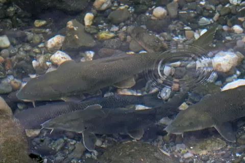
The new tool predicts, up to three weeks in advance, how at-risk fish populations are from heat across Switzerland. The predictions are based on three parameters: water temperature forecasts, fish physiology and species distribution. WSL's hydrological forecasting group developed the water temperature forecasts. "Our machine-learning model, trained on data from the past 10 years, uses the latest water temperature observations and weather forecasts to predict river temperatures", explains Ryan Padrón Flasher, one of the group's members.
Water temperature is the variable that matters most for river fish because they are ectotherms: their body temperature tracks the water around them and their metabolic rate rises with it. At the same time, warmer water holds less dissolved oxygen. A heatwave therefore squeezes fish from both sides, increasing what they need while reducing what is available, and the result can be mortality within days once conditions pass a threshold.
Forecasting river temperature is not the same as forecasting air temperature. A river's temperature responds to shading, groundwater inputs, discharge and how much water is being abstracted upstream, so models for this purpose are trained on observed river data rather than on air temperature alone. A machine-learning approach trained on a decade of observations can incorporate those local relationships without each one having to be written out as an equation.
Not all fish are equally sensitive to heat. Searching through published data, the authors gathered information on the temperature limits of 59 fish species found in Swiss rivers. This is the temperature at which their ability to swim, and therefore to escape from dangerous conditions, is impaired. The authors found non-native fish species to have a temperature tolerance 1.4°C higher than native species on average. The bighead carp (Hypophthalmichthys nobilis) held the highest tolerance of 32.3°C, while the burbot (Lota lota) was the least tolerant, with 24.1°C.
The threshold the researchers used — the temperature at which swimming ability is impaired — is deliberately functional rather than lethal. A fish that cannot swim effectively cannot move out of a warming reach, cannot hold position in a current, and cannot evade predators, so the point at which performance drops is often where a population becomes vulnerable even though it is not yet dying.
That native species showed a lower tolerance than non-native ones by about 1.4°C on average is the finding with the clearest management implication. It suggests that as Swiss rivers warm, the species already present are likely to be squeezed before the arrivals are, and that warming may favour fish that were introduced rather than those that evolved in these catchments.
The spread between the two extremes illustrates the point. A cold-water species such as the burbot becomes impaired at temperatures a warm-water carp tolerates comfortably, which is why a single national temperature threshold would be meaningless and why the tool works at the level of individual species.
Finally, as fish species are unevenly present across Switzerland, including information on their distribution makes the forecasts location specific. "It's a constant compromise between the complexity and quality of the model", explains Camille Albouy. "As the idea was to develop a map of risk for the whole of Switzerland, based on the best climate predictions, we had to keep it simple and focus on what matters for management."
Adding distribution is what turns a temperature forecast into a risk forecast. A stretch of river predicted to reach 28°C is only a risk if a species sensitive at that temperature actually lives there, which is why the same forecast produces different maps for different parts of the country.
Keeping the model simple was a stated design choice rather than a limitation of ambition. A tool intended for operational use across an entire country has to run on the data that are actually available everywhere, and adding detail that exists only for a handful of well-studied catchments would make the map inconsistent rather than more accurate.
With the help of hindsight
To evaluate the forecasts, the scientists applied their tool on data from summer 2018, when around three tonnes of river fish died in Switzerland. "We wanted to see how well we could retrospectively predict the observed fish mortality", says Camille Albouy. However, this proved more challenging than expected. "Data on fish mortality are limited," he clarifies, "so we reached out to practitioners to see if their observations matched our predictions."
The 2018 summer is the reference case because it is the event practitioners remember: European heatwaves that year pushed river temperatures high enough to produce visible fish mortality across several countries, and roughly three tonnes of dead fish were recorded in Swiss rivers.
Relying on practitioner observations highlights a structural gap. Fish kills are noticed and reported unevenly — a large die-off in a busy reach is recorded, a smaller one in a remote tributary may never be — so the datasets available for validating a model of this kind are incomplete by nature. Cross-checking predictions against what rangers and fishery managers actually saw is a way of testing the tool against the only evidence that exists.
The value of a three-week lead time is that it is long enough to act. Managers can restrict or close fishing in specific reaches, reduce abstractions, or prioritise monitoring of the populations flagged as most at risk, rather than responding after fish are already dead. Whether the tool gets used that way depends on the forecasts reaching the people who make those decisions in time.
Seabirds feed the reef fish below them; take the birds away and the food chain shifts
A second tongue-eating parasite turns up in Mexican snapper

An underwater proposal at Cape Town's Two Oceans aquarium wins hearts
First known transmissible cancer found in catfish
Six of Marineland's 30 belugas airlifted to safety

MPA Day returns, with events across South Africa's marine protected areas